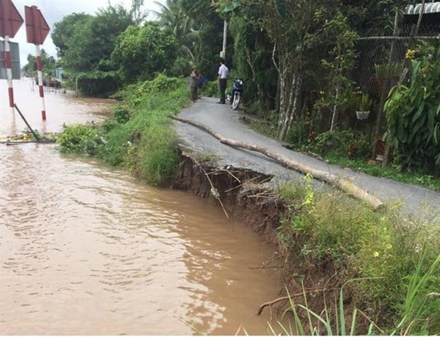
Landslide of Cai San canal, My Thanh ward, Long Xuyen city. (Photo: Thanh Sang / VNA)
On the afternoon of September 10, Mr. Tran Anh Thu, Vice Chairman of the People's Committee of An Giang province, said that the provincial People's Committee issued an emergency decision on landslide in Cai San canal from Nam Su canal to Sau Ba canal, My Thanh Ward, Long Xuyen City, An Giang Province. Cai San Rach, from Nam Su canal to Sau Ba canal, has occurred 4 times of subsidence and landslide since 2019. In particular, the wave happened on June 10, 2019, the crack was about 3-10cm, with a length of 40m, subsidence about 10cm deep, 60m downstream from Rach Nam Su.
Most recently, on May 25, there appeared subsidence, sliding the bank with a length of 175m, from Nam Su canal to Sau Ba canal, right at Cai San market and a concentrated residential area.
The crack is about 1-3cm wide, the bank subsidence is about 5cm, causing many temporary houses on the coastal piles, affecting 39 households living on this section.
According to Mr. Truong Kien Tho, Deputy Director of the Department of Agriculture and Rural Development of An Giang province, landslides from Nam Su canal to Sau Ba canal in the coming time will be complicated, tends to increase the level with warning length of 2,300m from the river Hau to the end of the My Thanh ward boundary.
"The cause of landslide in Cai San canal was initially identified as an area located on the bend, the pressure of strong currents close to shore during the pouring season, the opposite shore area in Thot Not district, Can Tho city, there is Many milling factories with many means of water circulation, turn around, cause the water flow to hit the bank of An Giang, causing landslides, "said Tho. According to the Department of Natural Resources and Environment of An Giang province, the topography of the riverbed of Cai San canal is mostly in a U-shape with the bottom deviating to the bank of My Thanh ward, the common recorded depth lying in the middle of the river bed from minus 6m to negative. 7.5m, the slope is quite steep. However, around the area, there was rift, collapse, the recorded depth is from minus 8m to minus 9.7m. This is the area where vortex appears in the pouring season, and is also the area where subsidence and shoreline cracks frequently occur as mentioned above.
The landslide of Cai San canal from Nam Su canal to Sau Ba canal, My Thanh ward, Long Xuyen city, is at a particularly dangerous level, causing direct danger to the Cai San market area, the residential area live in focus.
To ensure the safety of lives and property of the people and the State, the Department of Agriculture and Rural Development of An Giang province proposed the Provincial People's Committee to decide the emergency situation of landslide in Cai San canal from Nam Su canal to Sau Ba ditch.
The People's Committee of An Giang province assigns the Department of Natural Resources and Environment to localize the danger of landslide, and establish a safety corridor, The People's Committee of Long Xuyen city mobilizes the people to relocate their assets out of dangerous landslides and areas prone to dangerous landslides.
Mr. Tran Anh Thu, Vice Chairman of the People's Committee of An Giang province, said: The Provincial People's Committee also asked Long Xuyen city to put up signs and barriers to prevent people and vehicles from entering the landslide area.Watch force closely monitored the landslide developments and maintained security and order in the area.
The People's Committee of An Giang province also assigned Long Xuyen city to quickly select a consultant, organize to formulate an urgent handling plan, submit to the appraisal and approval of the plan to overcome the landslide; mobilize forces and materials to handle urgently in accordance with the law to limit the process of digging, excavating riverbeds, roadbeds and shorelines in the warning section in order to minimize landslides./.