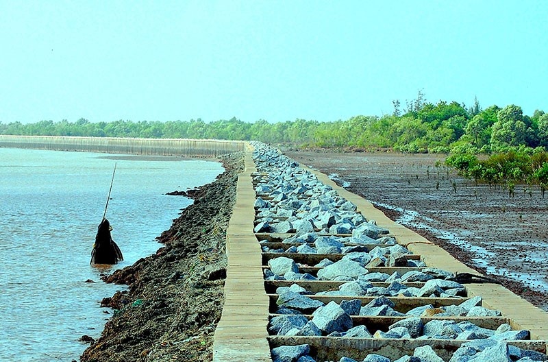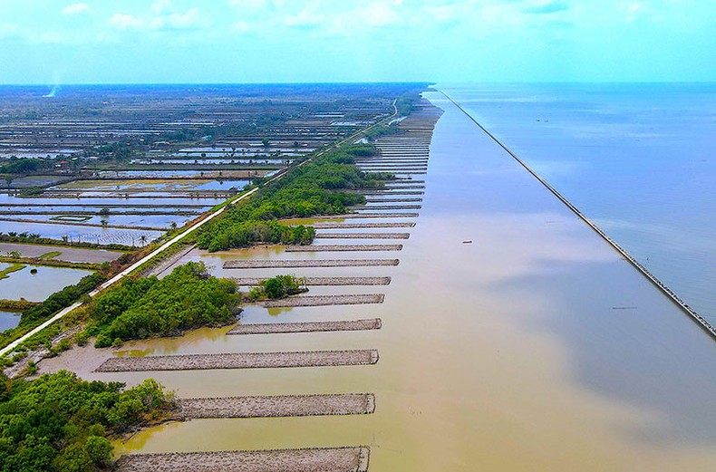
The protection forest is regenerated by the breakwater along the west coast of Ca Mau, part of Khanh Tien commune, U Minh district.
Thanks to the synchronous combination of structural and non-structural solutions, inside Ca Mau coastal breakwaters have formed alluvial ground, ideal conditions for forest trees to regenerate. In the coming time, inside the newly built breakwaters, there will be dense forest mats, enough to protect the sea dykes against big waves and high winds.
Conquer the waves
More than a decade ago, the West Ca Mau sea dyke was in a barren state, with no protective forest outside, directly attacked by fierce waves, the risk of dyke breaking was always present. In an emergency situation, the province has mobilized a large amount of human resources and materials... to participate in dyke protection. At places where the dyke is about to break like Huong Mai (2002), Rach Dinh (2010), the task force uses melaleuca poles and coconut poles to plug into the sea to prevent waves from hitting the shore directly.
However, in just a short time, these types of poles were knocked down by fierce waves. Engineers specializing in dykes and local irrigation devised a way to use gabion embankments to drop into the sea close to the dyke body. However, after only two or three seasons of rough seas, many gabion embankments have been oxidized, broken joints, and suffered the same "fate" as wooden embankments.
While waiting for "rescue" from the Ministry of Agriculture and Rural Development, irrigation experts in Ca Mau tinkered with and thought of a new way to respond to reduce the destruction of violent waves, but without having to reverse the dike. exist in the interior of the field. It is a way of placing two parallel rows of concrete piles on the far side of the dyke, putting rocks in the middle, and then attaching them with load-bearing beams. The above construction solution is called "prestressed centrifugal concrete embankment".
From a few initial pilot sections, after testing and realizing good results, Ca Mau gradually applied it to many very important landslide sites along the West coast, with priority given to places where there was no such thing. and protection forest trees, high dyke breaking pressure. “Since the sea embankment outside the dyke, I have seen that the waves on the shore are weaker, inside the embankment accumulates a lot of mud, after a long time the forest trees regenerate and turn into the lush green forests like now. Thanks to that, my family living behind the dyke is less afraid of strong waves causing the dyke to break”, said Mr. Nguyen Minh Chien, a household with more than 1ha of productive land, living for more than 40 years in hamlet 8, Khanh Tien commune, district. U Minh said.
Up to now, in Ca Mau, there are many sea embankment works along the west coast dike line. Most of them are "prestressed centrifugal concrete embankments", stretching from Ca Mau Cape all the way to Khanh Tien commune, bordering Kien Giang province.
Depending on different levels and completion times, behind the embankment works there are now regenerated forest beds. In the coastal area of U Minh district, where the first pilot sea embankment was built in Ca Mau, the forest floor has grown green from the embankment to the bottom of the dike. They are considered a solid "armor" protecting the West Sea dyke.
According to Mr. Bui Van Dong, Head of Ca Mau Dike Management, since ancient times, forest trees have been considered a pioneer "army" to break waves and reduce landslides in coastal areas. However, it will be very difficult to bring fish and mangrove trees out to grow along the coast, especially when the beach has been deeply eroded and there is no alluvial ground. “The young fish and mangrove trees not only cannot withstand the pressure of big waves that always hit the shore, but also have a high chance of being swept out to sea. When there is a wave-reducing embankment to shield the outside, inside the embankment, alluvium will be deposited, over time becoming an alluvial ground, creating conditions for forest trees to regenerate and develop into a protective forest to protect the dike from strong waves and high tides. ', Mr. Dong affirmed.
Deploying multiple solutions synchronously
The coastline of the whole Mekong Delta is more than 740km long, Ca Mau is home to the longest coastline with more than 250km. This is also the only locality in the region with up to three sides bordering the sea, which has long been a "hot spot" for landslides due to extreme impacts from various forms of climate change.
Landslides take place all year round, the protection forest is severely damaged, so the coastline encroaches rapidly towards the mainland. Statistics of the provincial forestry sector show that, in just 10 years (2011-2021), Ca Mau has lost coastal forests with an area of more than 5,200 ha (equivalent to the average area of a commune in the province). The total length of the coastline was eroded about 188km out of a total length of 254km.
During the same period, with the attention and support of the Government, ministries, central branches..., Ca Mau authorities and functional units have made efforts to invest in construction and completed 56, 7km of embankment protects the coastal area with a total cost of more than 1,840 billion VND. In which, the West Coast embankment investment is more than 43km long, with a cost of more than 1,100 billion VND; East coast 12.9km, implementation cost 745 billion.

Ca Mau province deploys afforestation behind the sea embankment works in order to shorten the time
recovery time of the protection forest belt.
“The coastal embankment works in Ca Mau with adequate capital and complete investment have brought into full play their effectiveness, helping to limit the impact of sea waves, prevent landslides and initially cause accretion and beach formation. nearly 1,000 ha of protection forest have been restored,” said Deputy Director of the Department of Agriculture and Rural Development To Quoc Nam.
In recent years, Ca Mau authorities have synchronously implemented many ways to restore forests in areas inside the sea embankment. In addition to the previous manual form, in 2021, the investor (Department of Agriculture and Rural Development) entrusts the Provincial Agriculture and Rural Development Project Management Board to implement the implementation. Currently, the planting, afforestation and forest care work behind the sea embankment area of U Minh district with a total length of about 9.7km, the section from Huong Mai to Tieu Dua and the T29 sluice area. Inside this area of the sea embankment, the functional unit uses mechanized gears with an average height of 0.5m, a width of 12m and a length of about 80m. After completion, each hectare of cassette surface can grow up to 3,300 white mam trees suitable for growing on alluvial land.
According to the Director of the Ca Mau Agricultural and Rural Development Project Management Board, Tran Thanh Ut, the planting and care of forest trees is included in the construction and installation bidding package No. West Ca Mau coastal mangrove forest, approved by the People's Committee of Ca Mau province in November 2021. By the end of 2022, package 57 has been completed, a total of 186 beds have been milled and forest trees have been planted.
In the recent re-survey, the Ca Mau coastal line is currently about 100km and continues to be eroded at different levels. In particular, the extremely dangerous level is about 35km in length, the average annual landslide speed is from 50-80m to the shore. With such a rapid erosion rate, if there is no immediate protection solution, Ca Mau will not only lose more land and coastal protection forests formed over hundreds of years, but also face a high risk of deep erosion. Inland, threatening many already built infrastructure works, the restoration will be very expensive, and at the same time, it will be difficult to restore the lost land and forests.
Implementing Decision No. 957/QD-TTg dated July 6, 2020 of the Prime Minister, the People's Committee of Ca Mau province directed the functional sector to review and update the landslide situation to supplement and adjust the plan. Plan for prevention and control of riverbank and coastal erosion in Ca Mau up to 2030 according to Plan No. 116/KH-UBND dated October 20, 2020. “According to new updated data, the landslide situation is up to about 100km, the total need for capital to respond is more than 3,900 billion VND. In particular, Ca Mau would like to give priority to support VND 970 billion in advance from the source exceeding the central budget revenue in 2022 so that the province can carry out landslide prevention and control works with a length of nearly 18km in urgent locations. proposed by To Quoc Nam.