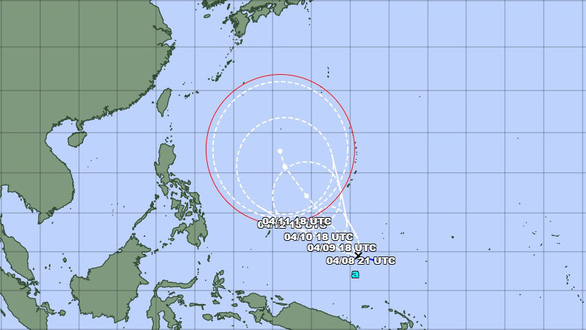
Typhoon Malakas is not forecast to enter the South China Sea (JMA image)
On the morning of April 8, the National Center for Hydro-meteorological Forecasting, citing information from the Pacific Northwest Tropical Storm Prediction Center (RSMC Tokyo), said that a tropical depression off the coast of the Philippines has strengthened into a typhoon. .
This is the first storm in the Northwest Pacific in 2022, internationally named Malakas.
The Japan Meteorological Agency (JMA) said that the storm was strong at level 8 (60-75km/h). In the next 24 hours, the storm will move to the northwest, about 15km per hour and unlikely to get stronger.
It is forecasted that in the coming days, the storm will mainly move in the northwest direction, possibly strengthening to level 12 (120-135km/h).
The National Center for Hydro-meteorological Forecasting forecasts that storms are unlikely to enter the East Sea.
However, in the first half of April, a tropical cyclone is likely to appear in the middle and southern areas of the East Sea.
Commenting on this year's storm season, Mr. Hoang Phuc Lam - deputy director of the National Center for Hydro-meteorological Forecasting - said that storms and tropical depressions are likely to appear in the East Sea earlier than in the central region. For many years, it is forecasted that there will be about 11-13 storms and tropical depressions in the East Sea and 5-6 storms likely to reach our country's mainland.
"It is necessary to watch out for strong storms with complicated movements and strong winds at sea in the months of the stormy season in 2022," Mr.Lam said.