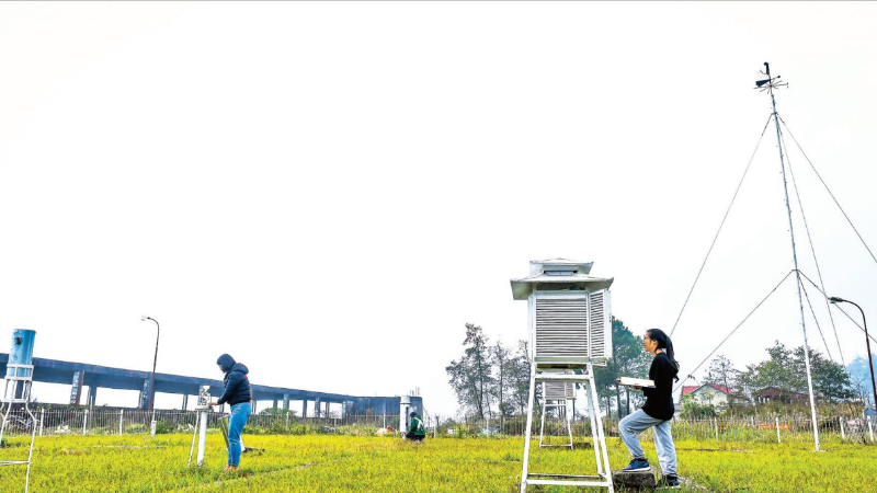
Early forecasting and warning services serve as the "first line of defense," playing a decisive role in protecting lives and assets. (Photo: TRONG TUNG)
In recent years, natural disasters in Vietnam have trended upward in both frequency and intensity, becoming increasingly extreme and unpredictable.
Between 2021 and 2025, the country averaged 10–12 storms and tropical depressions annually, alongside hundreds of heavy rain spells, floods, and landslides. Over these five years, disasters claimed more than 1,500 lives (including missing persons) and caused economic losses totaling hundreds of trillions of Vietnamese dong.
Notably, new characteristics have emerged in various disaster types, such as flash floods and landslides in mountainous regions, extreme urban rainfall, and severe drought and saltwater intrusion in the Mekong Delta. These phenomena often occur rapidly within narrow areas, making them difficult to predict yet devastating in impact.
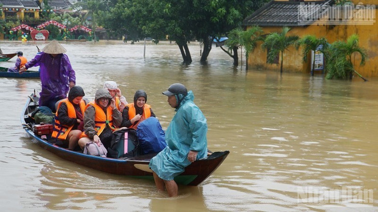
Natural disasters in Vietnam have trended upward in both frequency and intensity. (Photo: Nhan Dan Newspaper)
According to Mr. Le Cong Thanh, Deputy Minister of Agriculture and Environment, the more accurate the forecast and the earlier the warning, the higher the capacity for proactive response, thereby significantly mitigating damage. Practice has shown that forecasting and early warning systems are the "first line of defense," holding a decisive role in safeguarding people and property.
Dr. Nguyen Xuan Hien, Deputy Director of the National Center for Hydro-Meteorological Forecasting, noted that climate change is intensifying weather extremes globally and in Vietnam.
From 2011 to 2020, the global average surface temperature rose by approximately 1.09°C compared to pre-industrial levels. The period from 2015 to 2025 marked the 11 hottest years in the past 175 years. Specifically, 2025 was 1.44°C warmer than the 1850–1900 period, ranking as the third warmest year on record.
Vietnam has recorded numerous extreme events, such as the historic drought and saltwater intrusion in the Mekong Delta during the 2019–2020 dry season, and the 2020 historic floods in Central Vietnam characterized by "consecutive storms and overlapping floods."
In particular, Super Typhoon Yagi in September 2024 was recorded as the strongest storm to hit Northern Vietnam in 30 years, triggering record rainfall, historic flooding, and severe landslides. The year 2025 also saw a record-high number of storms and tropical depressions in the East Sea (South China Sea), including an extreme daily rainfall of 1,740mm at Bach Ma station (Hue City) and major floods occurring simultaneously across 21 river systems.
These developments create an urgent demand to enhance forecasting and early warning capacities to minimize loss.
Enhancing Capacity to Overcome Challenges
Experts suggest that Vietnam's hydro-meteorological forecasting system has made significant strides. Numerical weather prediction (NWP) models running on supercomputers now provide detailed data down to a 3x3km grid. Typhoon forecasting utilizes multi-model ensembles (global and regional) combined with data assimilation technologies.
The application of Artificial Intelligence (AI) is yielding clear results. Machine learning models have improved short-term storm intensity forecasts by 10%–20%, while automated storm recognition systems using satellite data have achieved over 90% accuracy.
For thunderstorms and tornadoes, integrated systems using satellite, radar, lightning detection, and rain gauge data can provide warnings 30 minutes to 3 hours in advance with 70%–90% accuracy. Real-time platforms for flash flood and landslide warnings have also been deployed down to the commune level.
Hydrological forecasting continues to improve, with flood lead times of 12–48 hours for rivers in the North and Central regions, and up to 5 days in the South. Early warnings can now reach 2–4 days, and even up to 10 days in certain areas.
However, limitations remain. The accuracy of heavy rain quantitative precipitation forecasts (QPF) is still low, long-term storm intensity forecasting has seen little improvement, and the lead time for peak flood predictions remains short. Notably, warning of flash floods and landslides at specific locations remains difficult due to a lack of real-time geological and topographical monitoring data.
Furthermore, data infrastructure, monitoring networks, and high-tech human resources have yet to meet requirements. Financial mechanisms and policies to attract resources for research and technological application are also limited.

Mr. Cao Duc Phat, Chairman of the Disaster Prevention Community Foundation, emphasized that in the context of increasingly extreme disasters, enhancing accurate forecasting and early warning capacity is a prerequisite for local authorities and residents to proactively prevent and minimize damage.
Addressing these practical requirements, Deputy Minister Le Cong Thanh stated that promoting modern technologies such as AI, Big Data, remote sensing, and high-resolution numerical models will open new pathways for the industry.
Under the direction of the Ministry of Agriculture and Environment, digital transformation in the hydro-meteorological sector will be accelerated through the construction of Big Data systems, modernization of monitoring networks, development of multi-hazard early warning platforms, and enhanced data sharing.
A key requirement is ensuring that forecast and warning information reaches the public as quickly and accessibly as possible via digital platforms, mobile devices, and multi-channel communication systems.
Moving forward, the hydro-meteorological sector is committed to mastering modern forecasting technologies, improving the quality of storm intensity and rainfall quantification, and developing localized early warning systems to ensure timely access for all citizens.